Swimming to the North Pole 2

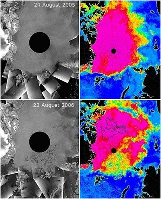
Here's some more pix to stick in your pipe and smoke, The black spot is the North Pole, the map of the UK is overlayed to give a sense of scale.
Here's an explanation of everything else from Softpedia:
Besides the fact that the ice sea is shrinking rapidly, scientists have now revealed that it also becomes more mobile and thin. The black and white images on the left are taken by Envisat ASAR (Courtesy of Polar View). The right colored images are from EOS Aqua AMSR-E ice concentration acquired on the same day (Courtesy of Leif Toudal Pedersen). In the colored AMSR-E images, ice cover, or the concentration of ice, is represented by the color. Pink represents pack ice and the color blue open water. Intermediate colors orange, yellow, and green indicate lower ice concentrations of 70%, 50% and 30%, respectively. In the ASAR images, the ice cover is represented by the uniform grey area which extends radially-outwards from the North Pole, represented by the central black circle. The 2006 images show fractures and openings in the sea-ice cover – just below the pole in both the ASAR image, seen as splashes of dark grey and black, and in the AMSR-E image (with British Isles shown for scale), seen by the high concentration of yellow, orange and green colors, signifying low ice concentrations.

No comments:
Post a Comment